The Trek - We Finally Gain Some Real Altitude!
DAY 5:
The 5th day of our adventure is another one of transit. An early flight from Cusco to Lima, a quick bus ride in Lima to get to a bus depot, and an incredible 8 hour bus ride to Huaraz, a booming town in the heart of the Cordillera Blanca in the valley of Callejon de Huaylas.
On our way from Lima to Huaraz, we were again struck by the transition from a large city to small towns dominated by the Quechuan culture. More surprisingly to us was the immense desert surrounding Lima. It actually took hours to begin to see some signs of life and greenery.


The bus ride from Lima to Huaraz...hours of sand.
The valley in which Huaraz is situated is actually one of the best places in South America to enjoy superb mountain scenery and plenty of outdoor activities such as trekking, mountain climbing, mountain biking, skiing and rafting. As a result, the town of Huaraz has the feel of a western boom town catering in all possible ways to the adventure seeker.
The 40 km wide valley runs north-south for nearly 200 km between the snow-capped mountains of the Cordillera Blanca (White Mountains) to the east and the Cordillera Negra (Black Mountains) to the west. The setting of Huaraz, at the foot of the Cordillera Blanca, at an altitude of 3090 m (10100 ft.), is spectacular. You can see over 20 snow-capped peaks over 5000 meters (16,400 ft.), of which the most notable is Huascaran (6,768m or 22200 ft), the highest mountain in Peru.
Since we arrived late at our hotel from a very long trip, we had to call it an early night with the hope that the next day would provide us with an opportunity to explore the town.
DAY 6:
This is the day we finally get tested at some real altitude; this is the day of our acclimatization hike. We are to climb to Laguna Churup, a beautiful lake located at an altitude of 4450 meters (14,600 ft) in the shadows of the Nevada Churup mountain which stands at 5495 meters (18,030 ft.). To put this in perspective, the highest peak in the rockies is Mount Elbert at 4,400 metres or 14,433 ft; the FAA requires oxygen in aircraft cabins for flights above 3,800 m or 12,500 ft; and the CN Tower is a mere 553 metres.

Our starting point. Caro and Andree are keen to head off.

As we begin our first day in the mountains, we have the feeling of walking into a postcard....with Nevada Churup looming in the background.
In order to get to the starting point we must take once again another bus thru some precarious terrain to the base of Churup mountain at an altitude of about 4,200m (13,780 ft.). The climb seemed at first very reasonable until we realized the pace could be nowhere as fast as we anticipated. Our new guide, Guio, carefully takes us up the slope one very slow step at a time. Tristan and I thought this rather tedious until we realized that after no more than 10 minutes of walking we were quickly running out of breath!

Nevada Churup looms closer as we progress.
Having taken herself off the Diamox, Andree's day does not start well. She has a headache and feels nauseous. This is definitely her "bad day" as she struggles up the mountain path.
On one part of the trail, we encountered some ice. Andree slips but luckily she does not fall far. We were on a tight switchback portion of the trail and Tristan was right below her and in the perfect spot to catch her.

Suffering from the symptoms of altitude sickness, this would not be a good day for Andree.
In the clear mountain air this hike was exhilirating. I did however start to get congested and began to feel a cold coming on (something that would not do me well in the later part of our trek).
We eventually found our way to a gorgeous water fall. Surprisingly, the guide indicated we would hike up the side of the fall. This obviously required some serious climbing. For Connie, this was quite a new experience and for a while she required some help from Guio as she did not know where to place her feet on the slippery stones.

A gorgeous water fall descends some 100 metres or 300 feet. We needed to climb it and end up doing so on the right side.
Once up the water fall, we were greeted with the beautiful azur coloured Laguna Churup where we had a snack consisting of Kiwichan energy bars and "Indian Grenadine". Kiwichan is similar to quenoa and consists of the seed of an ancient cereal grain of Peru, related to amaranth. It has a mild nutty flavor. Later in the trek we would have Kiwichan as a porridge-type breakfast and as a base for some of our soups.
Indian Grenadine was a coarse-skinned orange fruit with a slimy green interior consisting of many edible seeds; it is both sour and sweet and reminescent of citrus fruits.

Laguna Churup at 4,450 metres.

Indian Grenadine.
Aside from the treacherous water fall, our return to base was non eventful. Once we were back at our bus, we stopped for lunch.
Not far away some Quechua locals were grazing their animals and were also having lunch. Surprisingly one man came to join us with a brightly coloured red and gold cloth in which were baked potatoes and beans. These he offered to our team.

Guio helps Andree with her footing as we climb our way back down the waterfall.
We knew Peru was known for its thousands of species of potatoes. Of course, I found myself with one I had never tasted before. It resembled a conventional red-skinned potatoe until I split it open. Inside, the meal of the potatoe was yellowish white but striped purple-red! I don't know if it was the hunger generated by the hike, but this seemed one of the tastiest potatoes I've ever had.
This episode is an example of one of the most well known features of the Quechuan culture. This culture places great emphasis on community and mutual help. The social system is based on reciprocity: you help your neighbors, they do something for you in return.

Although early winter, we were surrounded with flowers of all kinds, in this case, "Devil's Shoe".
On our way back to Huaraz, our guide prepared our own offer to these local Quechuan. We returned the cloth, in which the beans and potatoes were carefully offered, with fruits (apples, indian grenadines, bananas and mandarins) from our own lunch packs.
It was now time to go back to Huaraz and see the town.

The main street of Huaraz.
The first thing that strikes you on arrival in Huaraz is that it cannot exactly be called a pretty place, with most of the buildings built from concrete. This is because the town was completely rebuilt following a catastrophic earthquake in 1970 which flattened all but one street of buildings and killed half of the city's population.
Our evening ended with a trip to the local market and the last meal we would have in a civilized environment for the next 10 days.
DAY 7:
Today we wake at 6:00 AM for a 7:30 departure. We actually have another 3 1/2 hour bus ride to our starting point, the trail head at Cashapampa (2,900 m or 9500 ft.).


On the way we stop at a small town where once afain festivities are underway. This is another opportunity to glimpse local Quechuan women in colourful traditional dress.
Cashapampa is our first opportunity to meet our expedition team. In addition to our guide Guio, we will be accompanied by Santos, the donkey driver, and his assistant Victor. We will also be accompanied by a cook, Raul, and his assistant Jose. When they call down the donkeys and horses (14 animals in all!), this adventure really started to have the feel of a real expedition.


It finally hits us, we're going on a real expedition. No one anticipated the large amount of equipment and food we would be taking along, nor the number of animals that would be joining us (9 donkeys and 5 horses!).
The trail begins with a pleasant walk thru a narrow valley. As we start we see a few farm houses idealically situated in a lush green setting. Strange fowl of all kind picking their way in the narrow paths surrounding each scantily built house.
An old woman washes her clothing in a clear mountain stream; next to her is presumably her grandchild. Not far away a pig rummages, tied by a home-made leash to a tree.


Along a well-defined path, we head off into a lush valley following clear streams fed by mountain glaciers.
The weather is hot and while our guide is wearing pants, we are all in shorts....something we would all regret. Of course, all of us were bitten by bugs.
After a couple of hours, we stop for lunch by a clear mountain stream. This is where we are introduced to the work of Raul and Jose. Clearly we will not suffer from hunger on this trek. The food would be better then anything we had at the local restaurants.

Caro, Connie, Steve and Andree at our first camp in LLamacorral.
We continued our moderate climb to our first camp: Llamacoral (3,800 m or 12,500 ft). On the way we spot an eagle flying by (the local eagle called Caracara); we also spot a large owl and yes...a Condor. We would see a Condor almost every day. But the height at which these birds soar is impressive and taking a good picture proved very difficult.

In the strangest places, you find beutiful things. A cactus flower blooms a few feet from our latrine.
Raul's dinner that night was impressive and included trout with a Yuca-based soup. We found out that for the rest of the trek our team would be procuring our meat from the locals all along the way. We finished the evening with Oregano tea, staring at a bright sky so full of stars we felt in the middle of the galaxy.
Tonite, Tristan and I follow Andree's lead and get off the Diamox (the pills that would help combat altitude sickness).
DAY 8:
Today we wake at 6:00 AM, hoping once again for an early start. I am up a half hour early and just before sunrise, I am struck by the brightness Venus, the one lone remaining "star". We begin our day with what would become a ritual: hot coca tea.

Tristan begins the day feeling the impact of the bug bites he received the day before. One of his hands is greatly swollen. Evenually antihistamines brought the swelling down.
This stage is to be the most comfortable in slope; much of the hike consist of crossing a great pampa (or field) enjoying of the views of many 5000m plus peaks and lakes. Most impressive of all though are the views of the Alpamayo; although not the highest mountain in Peru, it is the most prominent and recognizable peaks looming at over 5,940m (19,480 ft.).

Our day is a gentle climb along lakes and pampas.
Once again, we begin the hike in a lush green environment, at an altitude where in most mountain ranges we would be well above the tree line. We spot large hummingbirds, hawks, eagles, and yes again....condors, along the way. Amidst flora of all kinds we spend 4 hours hiking a gentle slope across lush green pampas before stopping for lunch.

By the side of a lake, amid Lupins and ancient stone walls, we stop for break. I discover my first blister...it will never become a serious issue on this trek. This time I have the right equipment...and my trusted duct tape.

Our donkey train passes by us during break.
I still cannot avoid the feeling of walking into a large three dimensional post card.

Although much of our trek is in a National Park, Quechua people still live on this land. Along the way, we pass a Quechuan couple (the woman holding a baby) next to their home a very basic structure with earthen walls. They sold Coca Cola and beer on this well-travelled path.


This day was a day of circumnavigating pampas and lakes.

Walking into a 3D poscard.
As we stopped for lunch, in the shadows of a glacier, some of us explore the pampas. Of all things, Andree finds a horse shoe in the middle of nowhere!

What an idealic setting for lunch: a pampa fed by an immense water fall streaming from an ancient glacier.

A large Lupin stands in the foreground, with the Alpamayo in the far distance.
We finish our hike at Taullipampa, at an altitude of 4200m (13,780 ft.) where our camp is set up. Taulli is Quechua for Lupin. We would often finds ourselves walking thru fields of these purple pea-like flowers. In some places, the Quechua grow them for their edible seed pods.

Caro prepares her gear for the night at our second camp, in the shadow of Taulliraju (roughly translated, "raju" is Quechua for ice mountain).
As I try to keep up with my journal, I rapidly learn that pens do not work very well at altitude...I should have brought a pencil.

Everywhere on this trek some sort of flower was blooming.
DAY 9:
Today we start off at 07:30 again. Our objective is to climb to the Punta Union pass at 4,750 m (15,580 ft.). Outside of Caro, this will be the highest altitude anyone of us will have ever been at up this point.
The day starts off cold as we aim to climb from Taullipampa at 4250m to go to our highest point yet the Punta Union Pass at 4750 m.
Today I start with a headache, similar to having a hangover. My cold is progressing and I cough quite a bit since my lungs are congested. This night was very cold and Tristan makes a note that next time we need sleeping bags that are rated for well below 0 degrees C.

As we head off, you would think Tristan is posing for a Mountain Equipment ad.
Our ascent continues with a steep climb across screes, fringing the shores of a turquoise lake called Taullicocha. The panorama that unfolds as we approach the pass at Punta Union provides one of the finest views of Peru: the nearby peaks of Chacraraju (6112 m), Artesonraju (6025 m) and Piramide (5885 m) as well as Alpamayo (5947 m), Santa Cruz (6259 m) and Huandoy (6395 m).


With Taulliraju on our left, the climb to the Punta Union Pass is slow, but steady.
It is at the pass that we break while our donkeys take the lead. Santos has a noticeable wad of coca in cheeks....and he's still stuffing it one leaf at a time.

In the distance, our donkey train inches its way up behind us.
Once again we see eagles and condors. This time we also spot some mountain rabbits. These are not your average cotton tails. They are almost twice the size with a dark fur (browninsh in colour) and surprisingly large tails. I never managed to catch one on film, but as they were running away from us, I could swear that they looked like rabbits with squirrel tails.

At 4750 m, Punta Union Pass is like a gateway carved in stone and providing a bridge between two immense valleys dominated by mountains.

Looking back to the pass. Nothing can provide a sense of scale, our path was a tiny notch in the rock no longer recognizable at this distance.
After a steep descent, passing the Laguna Morococha, we reach Quebrada Huaripampa, a lovely valley of meadows and small lakes. Then continue to Alto de Pucaraju (4640 m) with our day ending in Quebrada Tuctubamba (3800 m).

Once again, Raul and Jose find a perfect place for lunch.

Our "ambulance". On the side of Raul's "kitchen" a horse grazes. A fresh horse was always kept available in case of emergency.
As we end the day, I notice that I'm tightening my belt an extra 2 notches. It can't be because of lack of food. We are always eating so well, thanks to Raul and Jose. I imagine it's simply the great exercise and the mountain air. Problem is, I have no more notches to go!

As we approach our camp, this picture provides a good sense of scale. Our tents our up. Can you spot them?
DAY 10:
Today I wake again at 5:30AM. I've had a bad sleep and my cold is getting worse. My cough keeps me up for a good portion of the night. Connie has taken the habit of slipping her "camel pack" with hot water in her sleeping bag and I'm determined to do the same with my water bottle hereonin.
Today from our camp at 3900 m, we are aiming to go to the Pucaraju Pass at 4650 m. As we look behind us, we see Mt. Contrahierbas (6,036 m/19,798 ft) and Taulliraju with the Punta Union Pass descending into the Santa Cruz Valley.
Today, Guio offers coca leaves to chew on. Tristan, Caro and I give it a shot. I'm not sure if it is due to the coca leaves or not, but even with my cold, this day was easy for me. I did not suffer from any headaches nor did I have any problems keeping up.

A waterfall lays bare the white granite of the Cordillera Blanca.
On the way to the pass, we fjord a water fall which provided us with a clear look into the rock of the mountain. Having washed away all soil, the water fall flowed over pure white granite. I had thought that Cordillera Blanca referred to the white summits, but I was wrong. In fact, it refers to this granite base of which the mountains are made.


The mountain scenery continues to be impressive and often is just incredible.


At the pass, Connie ponders the glaciers, Steve works diligently over his diary and Andree is back in her element.
After passing thru an incredible field of Lupins (even congested I could smell the flowers) and some yellow blooms called Churicu, we stopped for lunch and a traditional Peruvian chicken stew or Escavicha de Pollo. And once again, we spot a condor.


Descending into fields of Lupins and yellow "churicu".
We finish our day by crossing an Alpine valley on a high ledge, and then descended slowly to a small lagoon called Huecrococha where we set our camp at 3750 m.

Our latest camp at Huecrococha.
DAY 11:
Today we start a half hour later than we have been used to. We wake at 6:30AM and aim for a start at 8:00AM. The morning temperature is no more than 7 degrees C, but with the sun, it feels warm although clouds are threatening.
As we start this portion of the hike, we need to bring a horse in order to help us cross a glacial river. Tristan lucks out and he's the chosen rider until we fjord the river. Apparently this is a trial run since we will need to do the same the following day.

Tristan lucks out and gets to ride a horse for the first portion of our hike.

Cowboy Steve looked mighty comfortable on a horse when it came to crossing our river.
It is still unbelievable to be trekking at an altitude of over 4000 m and yet still see lush vegetation. Most other mountain ranges would be bare at this altitude.

At over 4000 m we have a break at what still resembles a jungle-like atmosphere.
We cross a grassy slope and wind our way to another pass; this time not so high (at about 4400m). We spot eagles and hawks and with the cloudy sky, the temperature that climbs to 12 degrees, feels colder than it really is.
Then comes a site that for me would be the most memorable of the expedition. We descend into a valley where some Quechua people farm the land for potatoes, corn and the ever present Lupins. Kids approach us begging for "caramelo" (candy).

As we approached a settlement, a little girl ran across the fields to cross our path. She left us clutching the apple that Caro offered.
At one point a girl approaches Tristan and I and asks for a pencil! This was difficult to turn down. I actually had one pencil. I had been using it to roll my duct tape; I quickly unrolled it all, put it on my walking stick and gave her the pencil. When other kids asked for pencils (when we had no more goodies or fruits to share), I felt terrible not having conceived that we could have and should have brought some pencils and paper.


Amidst fields of Lupins, we approach a Quechua settlement with the mountains looming high in the background.
Although "dirt poor", the children seemed happy and well fed. Their parents never approached us for anything. When they did, it was to our guide that they directed their attention. Their only need: basic medicine for stomach aches, sore throats or the flu.


Whereas Caro captured the attention of the children by showing them "instant" digital photos, for some reason, Steve captured the attention of the local piglets.
As we got further down into the valley, we passed a few homes of stone and earthen walls. Pigs, cows and sheep were grazing everywhere. Ancient stone walls extended well into distance and in the background, a massif above which an immense glacier seemed precariously poised.

Ancient stone walls fade into the distance as we approach the massif on the right.
This glacier, thru dozens of water falls, fed a marshy pampa primarily composed of peat moss. Birds of various kinds could be seen (including Ibis) while horses grazed. All of this in the middle of a tapestry of fields covering the sides of the mountains.
We had arrived at Jancapampa, where we were to camp below the massif at 3,850 m /12,628 ft.


These pictures provide a sense of scale as we approach the massif. The white "veins" in the rock wall are actually inmmense water falls.
To our surprise we even had a local "welcoming committee" of sorts. Women and children of the area had gathered at the camp waiting for our arrival. They were selling Coca Cola and beer, as well as some of their woolen knittings.

Our "welcoming committee".


The children stole our hearts!
We finished our day with a warm meal while Raoul prepared popcorn to share with our visitors.

Santos, our donkey driver, distributes the popcorn.
As the night sky grew light with stars, like rolling thunder, we heard avalanches overhead....and we would continue hearing avalanches all night.

Our camp in the shadow of the massif.
DAY 12:
We went back to our routine and started the day early once again. This day begins with another river crossing. This time our horse is not so accomodating and Santos is called on to drag the animal across the water.

Looking back on the valley of Jancapampa, horses graze amidst a tapestry of fields as if a multicoloured quilt had been set to cover the hills.
From our campsite, we ascended steeply through a sparse forest, past grassy meadows. The clouds are threatening as a large field mouse crosses our path. We are hit by some rain and the walk is no longer pleasant, although the scenery remains magnificent.

As we begin our climb, we still find ourselves surrounded by lush forest.

As we exit the forest, we leave behind another isolated Quechua home.

As we approach the pass, we get a clear view of the lush valley we have just crossed.
Eventually we manage to stop for lunch just before reaching a scree slope below the Yanajanca pass (4,400 m/14,600ft). Both sides of this slope are defined by glacially polished cliffs. Here, Tristan discovers the red Rocoto pepper. A long time fan of very hot sauces and peppers, Tristan finally meets his match (I'm not sure how he's going to achieve this, but he is now determined to grow his own Rocoto in Canada).

Next to our lunch break, one of our donkeys grazes with another series of glaciers in the distance.

Raul and Jose set up for lunch with the precarious Yanajanca pass looming in the distance.

A closer view at the steep and dangerous scree pass where a condor takes us by surprise.
As we wind our way up the dangerous scree slope, a condor flies right above our heads. It's almost like having an animal the size of Buick sweep over your shoulders. In a precarious position I quickly try to get my first shot of a condor, but to my dismay, by the time I get my equipment set up, he has managed to effortlessly float hundreds of meters away.

Although all smiles, the weather is turning cold and nasty as we break at the top of the pass.

Looking ahead at the valley we will be descending into.
From the narrow pass we descended to the settlement of Huillca at 3,600m/13,400 ft, where we camp. As we arrive we pass once again by a Quechuan family, the children playing with a small goat. To our surprise, we find our camp surrounded by a herd of Alpaca...later it would be sheep.

As we approach our camp we come upon a Quechua settlement. Our guide's one word of caution: beware of the dogs.

As we pass the Quechuan settlement we encounter a family whose children were proud to show us their baby goat.
As we settle in for camp, the weather turns foul. It rains intermittently.


To our glee, we found our camp surrounded by a herd of Alpacas.
That evening, Guio, our guide, and Santos disappear to buy a sheep. Connie is truly dismayed as she clearly understood Guio to say he was off to buy "cheap" meat.

Intermitant showers put the camp at the end of a rainbow.
DAY 13:
We begin this day on a rather cold note: 2 degrees C. At least the day starts sunny, but again I did not sleep well as my couh is getting worse. As we start out along our path, 2 lone Alpacas seem to wish us goodbye.

In the morning, children from the Quechua settlement come to see us off.

Two lone Alpacas cross our path as we head off.
Today, we will be crossing 2 passes: the Mesapata pass at 4630 m. and the Carcara pass at 4850 m. As the clouds start to obscure the sun, I find the first pass rather difficult. Furthermore, making the day bleaker, we are having difficulty seeing the many peaks that loom around us.

The long walk to the first pass begins under ideallic sunny conditions.

Taking a break on the way to the Mesapata pass.

Clouds begin to obscure our view of the peaks surrounding us.
Having crossed the Mesapata pass we continued along the Moyobamba Valley. Far in the distance looms the Caracara pass. Along the way we spot another 2 condors.

A strange flora greets us at our next lunch stop, like pin cushions on a thin layer of ice.
As we climb to the Caracara pass, clouds descend upon us. By the time we are at the pass an incredibly strong wind threatens to blow us off the face of the mountain. The weather turns bone-chilling cold.

Climbing to Caracara, the weather continues to look bleak.

At the pass, we are huddled against the wind; it is hard to believe the rapid change in weather.
As we descend toward Jancarurish, things get progressively worse. We are first immersed in a hail storm where pellets flying horizontally scrub our faces like sandpaper. Visibility is no more than 10 m or 30 ft. Things calm down as we further descend, but they are no more pleasant as we progress into snow and then heavy cold rain.

A hail storm takes us by surprise.

In the rain, Connie descends into the valley.
By the time we reach the valley, we are totaly depressed as we have to hike up another ridge before finding our long way to a rain-soaked camp at 4200 m.

Another long and wet ridge to climb before finding our way to camp.
Here we should have had the opportunity to see the north face of Alpamayo, but with the heavy clouds, we see nothing of the peaks surrounding us.
DAY 14:
It has rained all night and our clothes and sleeping bags are damp. This does not help my cold. The temperature in the morning is no more than 4 degrees C. The clouds are still threatening, but as the sun peeks through there is some hope for better weather.
Today , we descend slowly down the valley until it becomes the Cedro Quebrada. As we follow a ridge we pass ancient Inca walls and the remnants of hundreds of terrasses. An elderly Quechua man washes some clothing in a small crystal-clear stream.


The start of this day takes us thru the Inca ruins.
We go up a never-ending series of switchbacks. Breathing for me becomes difficult so I keep my head down staring at the path before us. Once, I looked up to see a Quechua woman with a baby and a donkey just ahead of us. I'm not sure how we got to be just behind her, however 5 minutes later she had just as quickly disappeared...obviously following her own path up the mountain.

Across our ridge, the mountain sides are scarred by hundreds of terraces.

Feeling on top of the world as we reach the Juan Viento pass.
We spot more condors and rabbits and once at the Juan Viento pass (4,730 m), we stop for lunch where I finally get a clear shot of the elusive condors.

Finally caught a condor soaring overhead.

When your nights are not the greatest, it's amazing how comfortable stone can get.
From here we descend to camp at Osoruri where we set up our highest camp of the trip yet at 4,512 m. /14,800ft. Having just unpacked, a young Quechua girl and a donkey calmly pass on front of my tent entrance. Tristan and I are set up right on the foot path.

Looking down at our highest camp yet.

A Lupin stands guard next to our tent.
As we prepare for sleep I cannot stop coughing. In an attempt to sooth my congestion, Guio asks Raul to prepare a tea of local herbs. Using what looks like a furry plant from outer space, Raoul creates a brew that I ingest before going back to my tent for the night. The drink has a very earthy taste somewhat reminescent of spinach and actually suppresses my cough for at least half the night.
DAY 15:
This is my bad day.
My cough returned in the early morning and was agravated by sleep apnea. I would have been lucky if I had more than 2 hours of sleep. Every moment I dozed off, I quickly awoke in panic for fear of not having enough oxygen. In turn, the resulting deep inhalations sent me on a coughing spree.
Our tent was on a slight slope. Every half hour I would crawl to the top corner. I knew the next morning would be hard because every moment of crawling also had me out of breath. Even a quick trip to the latrine in the early morning (no more than 10m or 30 ft away) felt like a 100 m dash to my cardiovascular system.


The long and winding road ahead.

The way I feel today, proper hydration is essential. I will have consumed over 4 litres of water by the time this day is done.
Our day starts no better than the preceding: 4 degrees C., overcast, wet and gloomy. Clouds limit our visibility as we aim to reach the highest pass yet: Toro Pishtañan at 4,870 m (15,975 ft). To put this one in perspective, the highest peak in Western Europe is Mont Blanc in the Alpes which stands at 4,808 m or (15,774 ft.).

The weather is cold and overcast, often preventing a clear view of the many peaks around us.
As we climb along a ridge an then through many switchbacks to our destined altitude, I am very slow and my breating is so heavy I sound like a locomotive. Every step, takes two deep breaths and by the time I reach our pass, I feel like I've run a marathon.

The team reaches the highest altitude of this trek: 4,870 m.
Having reached the highest point of this trek, we then descend into the magnificient cirque of Mt. Santa Cruz, Piramide and Paron overlooking the deep blue turquoise Cuillicocha Lake, a jewel of the National Park of Huascarán. Here we stop for lunch at an altitude of approximately 4600 m. However, a heavy fog prevents us from seeing the magnificent peaks that presumably surround us.


The deep blue Cuillicocha Lake.
We take a last look at Santa Cruz and from there the trail descends slowly to Huishcash our final camp.
Here Guio and the team work up a feast to commemorate our trip. Using the lamb they acquired and slaughtered earlier in this trip, they prepare a Pachamanca, a traditional Peruvian meal cooked in the earth. Various meats and potatoes are prepared and in the space of no more than 45 minutes we are presented with a veritable feast.


Recipe for Pachamanca.
This memorable evening is effectively our last night under the stars. And although the trek was trying at times, we are already reminescing about the events that most touched us on this adventure.


Our last night in the Peruvian Andes and we were already growing sentimental.
DAY 16:
Our last morning in the mountains and from camp we first descend steeply and then walk accross a slope to Hualacayan to reach the roadhead.

Everything warms up as we make a final descend into the valley below.
Our bus and trusted driver meet us there to take us back to Huaraz in a 3 1/2 hour drive through the Santa Valley.

A welcomed site. Our bus waits at the exit of the national park.

One last handout for the children that greet us at our pick up point.
The 5th day of our adventure is another one of transit. An early flight from Cusco to Lima, a quick bus ride in Lima to get to a bus depot, and an incredible 8 hour bus ride to Huaraz, a booming town in the heart of the Cordillera Blanca in the valley of Callejon de Huaylas.
On our way from Lima to Huaraz, we were again struck by the transition from a large city to small towns dominated by the Quechuan culture. More surprisingly to us was the immense desert surrounding Lima. It actually took hours to begin to see some signs of life and greenery.


The bus ride from Lima to Huaraz...hours of sand.
The valley in which Huaraz is situated is actually one of the best places in South America to enjoy superb mountain scenery and plenty of outdoor activities such as trekking, mountain climbing, mountain biking, skiing and rafting. As a result, the town of Huaraz has the feel of a western boom town catering in all possible ways to the adventure seeker.
The 40 km wide valley runs north-south for nearly 200 km between the snow-capped mountains of the Cordillera Blanca (White Mountains) to the east and the Cordillera Negra (Black Mountains) to the west. The setting of Huaraz, at the foot of the Cordillera Blanca, at an altitude of 3090 m (10100 ft.), is spectacular. You can see over 20 snow-capped peaks over 5000 meters (16,400 ft.), of which the most notable is Huascaran (6,768m or 22200 ft), the highest mountain in Peru.
Since we arrived late at our hotel from a very long trip, we had to call it an early night with the hope that the next day would provide us with an opportunity to explore the town.
DAY 6:
This is the day we finally get tested at some real altitude; this is the day of our acclimatization hike. We are to climb to Laguna Churup, a beautiful lake located at an altitude of 4450 meters (14,600 ft) in the shadows of the Nevada Churup mountain which stands at 5495 meters (18,030 ft.). To put this in perspective, the highest peak in the rockies is Mount Elbert at 4,400 metres or 14,433 ft; the FAA requires oxygen in aircraft cabins for flights above 3,800 m or 12,500 ft; and the CN Tower is a mere 553 metres.

Our starting point. Caro and Andree are keen to head off.

As we begin our first day in the mountains, we have the feeling of walking into a postcard....with Nevada Churup looming in the background.
In order to get to the starting point we must take once again another bus thru some precarious terrain to the base of Churup mountain at an altitude of about 4,200m (13,780 ft.). The climb seemed at first very reasonable until we realized the pace could be nowhere as fast as we anticipated. Our new guide, Guio, carefully takes us up the slope one very slow step at a time. Tristan and I thought this rather tedious until we realized that after no more than 10 minutes of walking we were quickly running out of breath!

Nevada Churup looms closer as we progress.
Having taken herself off the Diamox, Andree's day does not start well. She has a headache and feels nauseous. This is definitely her "bad day" as she struggles up the mountain path.
On one part of the trail, we encountered some ice. Andree slips but luckily she does not fall far. We were on a tight switchback portion of the trail and Tristan was right below her and in the perfect spot to catch her.

Suffering from the symptoms of altitude sickness, this would not be a good day for Andree.
In the clear mountain air this hike was exhilirating. I did however start to get congested and began to feel a cold coming on (something that would not do me well in the later part of our trek).
We eventually found our way to a gorgeous water fall. Surprisingly, the guide indicated we would hike up the side of the fall. This obviously required some serious climbing. For Connie, this was quite a new experience and for a while she required some help from Guio as she did not know where to place her feet on the slippery stones.

A gorgeous water fall descends some 100 metres or 300 feet. We needed to climb it and end up doing so on the right side.
Once up the water fall, we were greeted with the beautiful azur coloured Laguna Churup where we had a snack consisting of Kiwichan energy bars and "Indian Grenadine". Kiwichan is similar to quenoa and consists of the seed of an ancient cereal grain of Peru, related to amaranth. It has a mild nutty flavor. Later in the trek we would have Kiwichan as a porridge-type breakfast and as a base for some of our soups.
Indian Grenadine was a coarse-skinned orange fruit with a slimy green interior consisting of many edible seeds; it is both sour and sweet and reminescent of citrus fruits.

Laguna Churup at 4,450 metres.

Indian Grenadine.
Aside from the treacherous water fall, our return to base was non eventful. Once we were back at our bus, we stopped for lunch.
Not far away some Quechua locals were grazing their animals and were also having lunch. Surprisingly one man came to join us with a brightly coloured red and gold cloth in which were baked potatoes and beans. These he offered to our team.

Guio helps Andree with her footing as we climb our way back down the waterfall.
We knew Peru was known for its thousands of species of potatoes. Of course, I found myself with one I had never tasted before. It resembled a conventional red-skinned potatoe until I split it open. Inside, the meal of the potatoe was yellowish white but striped purple-red! I don't know if it was the hunger generated by the hike, but this seemed one of the tastiest potatoes I've ever had.
This episode is an example of one of the most well known features of the Quechuan culture. This culture places great emphasis on community and mutual help. The social system is based on reciprocity: you help your neighbors, they do something for you in return.

Although early winter, we were surrounded with flowers of all kinds, in this case, "Devil's Shoe".
On our way back to Huaraz, our guide prepared our own offer to these local Quechuan. We returned the cloth, in which the beans and potatoes were carefully offered, with fruits (apples, indian grenadines, bananas and mandarins) from our own lunch packs.
It was now time to go back to Huaraz and see the town.

The main street of Huaraz.
The first thing that strikes you on arrival in Huaraz is that it cannot exactly be called a pretty place, with most of the buildings built from concrete. This is because the town was completely rebuilt following a catastrophic earthquake in 1970 which flattened all but one street of buildings and killed half of the city's population.
Our evening ended with a trip to the local market and the last meal we would have in a civilized environment for the next 10 days.
DAY 7:
Today we wake at 6:00 AM for a 7:30 departure. We actually have another 3 1/2 hour bus ride to our starting point, the trail head at Cashapampa (2,900 m or 9500 ft.).


On the way we stop at a small town where once afain festivities are underway. This is another opportunity to glimpse local Quechuan women in colourful traditional dress.
Cashapampa is our first opportunity to meet our expedition team. In addition to our guide Guio, we will be accompanied by Santos, the donkey driver, and his assistant Victor. We will also be accompanied by a cook, Raul, and his assistant Jose. When they call down the donkeys and horses (14 animals in all!), this adventure really started to have the feel of a real expedition.


It finally hits us, we're going on a real expedition. No one anticipated the large amount of equipment and food we would be taking along, nor the number of animals that would be joining us (9 donkeys and 5 horses!).
The trail begins with a pleasant walk thru a narrow valley. As we start we see a few farm houses idealically situated in a lush green setting. Strange fowl of all kind picking their way in the narrow paths surrounding each scantily built house.
An old woman washes her clothing in a clear mountain stream; next to her is presumably her grandchild. Not far away a pig rummages, tied by a home-made leash to a tree.


Along a well-defined path, we head off into a lush valley following clear streams fed by mountain glaciers.
The weather is hot and while our guide is wearing pants, we are all in shorts....something we would all regret. Of course, all of us were bitten by bugs.
After a couple of hours, we stop for lunch by a clear mountain stream. This is where we are introduced to the work of Raul and Jose. Clearly we will not suffer from hunger on this trek. The food would be better then anything we had at the local restaurants.

Caro, Connie, Steve and Andree at our first camp in LLamacorral.
We continued our moderate climb to our first camp: Llamacoral (3,800 m or 12,500 ft). On the way we spot an eagle flying by (the local eagle called Caracara); we also spot a large owl and yes...a Condor. We would see a Condor almost every day. But the height at which these birds soar is impressive and taking a good picture proved very difficult.

In the strangest places, you find beutiful things. A cactus flower blooms a few feet from our latrine.
Raul's dinner that night was impressive and included trout with a Yuca-based soup. We found out that for the rest of the trek our team would be procuring our meat from the locals all along the way. We finished the evening with Oregano tea, staring at a bright sky so full of stars we felt in the middle of the galaxy.
Tonite, Tristan and I follow Andree's lead and get off the Diamox (the pills that would help combat altitude sickness).
DAY 8:
Today we wake at 6:00 AM, hoping once again for an early start. I am up a half hour early and just before sunrise, I am struck by the brightness Venus, the one lone remaining "star". We begin our day with what would become a ritual: hot coca tea.

Tristan begins the day feeling the impact of the bug bites he received the day before. One of his hands is greatly swollen. Evenually antihistamines brought the swelling down.
This stage is to be the most comfortable in slope; much of the hike consist of crossing a great pampa (or field) enjoying of the views of many 5000m plus peaks and lakes. Most impressive of all though are the views of the Alpamayo; although not the highest mountain in Peru, it is the most prominent and recognizable peaks looming at over 5,940m (19,480 ft.).

Our day is a gentle climb along lakes and pampas.
Once again, we begin the hike in a lush green environment, at an altitude where in most mountain ranges we would be well above the tree line. We spot large hummingbirds, hawks, eagles, and yes again....condors, along the way. Amidst flora of all kinds we spend 4 hours hiking a gentle slope across lush green pampas before stopping for lunch.

By the side of a lake, amid Lupins and ancient stone walls, we stop for break. I discover my first blister...it will never become a serious issue on this trek. This time I have the right equipment...and my trusted duct tape.

Our donkey train passes by us during break.
I still cannot avoid the feeling of walking into a large three dimensional post card.

Although much of our trek is in a National Park, Quechua people still live on this land. Along the way, we pass a Quechuan couple (the woman holding a baby) next to their home a very basic structure with earthen walls. They sold Coca Cola and beer on this well-travelled path.


This day was a day of circumnavigating pampas and lakes.

Walking into a 3D poscard.
As we stopped for lunch, in the shadows of a glacier, some of us explore the pampas. Of all things, Andree finds a horse shoe in the middle of nowhere!

What an idealic setting for lunch: a pampa fed by an immense water fall streaming from an ancient glacier.

A large Lupin stands in the foreground, with the Alpamayo in the far distance.
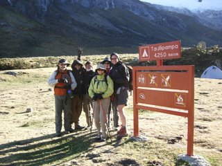
We finish our hike at Taullipampa, at an altitude of 4200m (13,780 ft.) where our camp is set up. Taulli is Quechua for Lupin. We would often finds ourselves walking thru fields of these purple pea-like flowers. In some places, the Quechua grow them for their edible seed pods.

Caro prepares her gear for the night at our second camp, in the shadow of Taulliraju (roughly translated, "raju" is Quechua for ice mountain).
As I try to keep up with my journal, I rapidly learn that pens do not work very well at altitude...I should have brought a pencil.

Everywhere on this trek some sort of flower was blooming.
DAY 9:
Today we start off at 07:30 again. Our objective is to climb to the Punta Union pass at 4,750 m (15,580 ft.). Outside of Caro, this will be the highest altitude anyone of us will have ever been at up this point.

The day starts off cold as we aim to climb from Taullipampa at 4250m to go to our highest point yet the Punta Union Pass at 4750 m.
Today I start with a headache, similar to having a hangover. My cold is progressing and I cough quite a bit since my lungs are congested. This night was very cold and Tristan makes a note that next time we need sleeping bags that are rated for well below 0 degrees C.

As we head off, you would think Tristan is posing for a Mountain Equipment ad.
Our ascent continues with a steep climb across screes, fringing the shores of a turquoise lake called Taullicocha. The panorama that unfolds as we approach the pass at Punta Union provides one of the finest views of Peru: the nearby peaks of Chacraraju (6112 m), Artesonraju (6025 m) and Piramide (5885 m) as well as Alpamayo (5947 m), Santa Cruz (6259 m) and Huandoy (6395 m).


With Taulliraju on our left, the climb to the Punta Union Pass is slow, but steady.
It is at the pass that we break while our donkeys take the lead. Santos has a noticeable wad of coca in cheeks....and he's still stuffing it one leaf at a time.

In the distance, our donkey train inches its way up behind us.
Once again we see eagles and condors. This time we also spot some mountain rabbits. These are not your average cotton tails. They are almost twice the size with a dark fur (browninsh in colour) and surprisingly large tails. I never managed to catch one on film, but as they were running away from us, I could swear that they looked like rabbits with squirrel tails.

At 4750 m, Punta Union Pass is like a gateway carved in stone and providing a bridge between two immense valleys dominated by mountains.

Looking back to the pass. Nothing can provide a sense of scale, our path was a tiny notch in the rock no longer recognizable at this distance.
After a steep descent, passing the Laguna Morococha, we reach Quebrada Huaripampa, a lovely valley of meadows and small lakes. Then continue to Alto de Pucaraju (4640 m) with our day ending in Quebrada Tuctubamba (3800 m).

Once again, Raul and Jose find a perfect place for lunch.

Our "ambulance". On the side of Raul's "kitchen" a horse grazes. A fresh horse was always kept available in case of emergency.
As we end the day, I notice that I'm tightening my belt an extra 2 notches. It can't be because of lack of food. We are always eating so well, thanks to Raul and Jose. I imagine it's simply the great exercise and the mountain air. Problem is, I have no more notches to go!

As we approach our camp, this picture provides a good sense of scale. Our tents our up. Can you spot them?
DAY 10:
Today I wake again at 5:30AM. I've had a bad sleep and my cold is getting worse. My cough keeps me up for a good portion of the night. Connie has taken the habit of slipping her "camel pack" with hot water in her sleeping bag and I'm determined to do the same with my water bottle hereonin.
Today from our camp at 3900 m, we are aiming to go to the Pucaraju Pass at 4650 m. As we look behind us, we see Mt. Contrahierbas (6,036 m/19,798 ft) and Taulliraju with the Punta Union Pass descending into the Santa Cruz Valley.
Today, Guio offers coca leaves to chew on. Tristan, Caro and I give it a shot. I'm not sure if it is due to the coca leaves or not, but even with my cold, this day was easy for me. I did not suffer from any headaches nor did I have any problems keeping up.

A waterfall lays bare the white granite of the Cordillera Blanca.
On the way to the pass, we fjord a water fall which provided us with a clear look into the rock of the mountain. Having washed away all soil, the water fall flowed over pure white granite. I had thought that Cordillera Blanca referred to the white summits, but I was wrong. In fact, it refers to this granite base of which the mountains are made.


The mountain scenery continues to be impressive and often is just incredible.


At the pass, Connie ponders the glaciers, Steve works diligently over his diary and Andree is back in her element.
After passing thru an incredible field of Lupins (even congested I could smell the flowers) and some yellow blooms called Churicu, we stopped for lunch and a traditional Peruvian chicken stew or Escavicha de Pollo. And once again, we spot a condor.


Descending into fields of Lupins and yellow "churicu".
We finish our day by crossing an Alpine valley on a high ledge, and then descended slowly to a small lagoon called Huecrococha where we set our camp at 3750 m.

Our latest camp at Huecrococha.
DAY 11:
Today we start a half hour later than we have been used to. We wake at 6:30AM and aim for a start at 8:00AM. The morning temperature is no more than 7 degrees C, but with the sun, it feels warm although clouds are threatening.
As we start this portion of the hike, we need to bring a horse in order to help us cross a glacial river. Tristan lucks out and he's the chosen rider until we fjord the river. Apparently this is a trial run since we will need to do the same the following day.

Tristan lucks out and gets to ride a horse for the first portion of our hike.

Cowboy Steve looked mighty comfortable on a horse when it came to crossing our river.
It is still unbelievable to be trekking at an altitude of over 4000 m and yet still see lush vegetation. Most other mountain ranges would be bare at this altitude.

At over 4000 m we have a break at what still resembles a jungle-like atmosphere.
We cross a grassy slope and wind our way to another pass; this time not so high (at about 4400m). We spot eagles and hawks and with the cloudy sky, the temperature that climbs to 12 degrees, feels colder than it really is.
Then comes a site that for me would be the most memorable of the expedition. We descend into a valley where some Quechua people farm the land for potatoes, corn and the ever present Lupins. Kids approach us begging for "caramelo" (candy).

As we approached a settlement, a little girl ran across the fields to cross our path. She left us clutching the apple that Caro offered.
At one point a girl approaches Tristan and I and asks for a pencil! This was difficult to turn down. I actually had one pencil. I had been using it to roll my duct tape; I quickly unrolled it all, put it on my walking stick and gave her the pencil. When other kids asked for pencils (when we had no more goodies or fruits to share), I felt terrible not having conceived that we could have and should have brought some pencils and paper.


Amidst fields of Lupins, we approach a Quechua settlement with the mountains looming high in the background.
Although "dirt poor", the children seemed happy and well fed. Their parents never approached us for anything. When they did, it was to our guide that they directed their attention. Their only need: basic medicine for stomach aches, sore throats or the flu.


Whereas Caro captured the attention of the children by showing them "instant" digital photos, for some reason, Steve captured the attention of the local piglets.
As we got further down into the valley, we passed a few homes of stone and earthen walls. Pigs, cows and sheep were grazing everywhere. Ancient stone walls extended well into distance and in the background, a massif above which an immense glacier seemed precariously poised.

Ancient stone walls fade into the distance as we approach the massif on the right.
This glacier, thru dozens of water falls, fed a marshy pampa primarily composed of peat moss. Birds of various kinds could be seen (including Ibis) while horses grazed. All of this in the middle of a tapestry of fields covering the sides of the mountains.
We had arrived at Jancapampa, where we were to camp below the massif at 3,850 m /12,628 ft.


These pictures provide a sense of scale as we approach the massif. The white "veins" in the rock wall are actually inmmense water falls.
To our surprise we even had a local "welcoming committee" of sorts. Women and children of the area had gathered at the camp waiting for our arrival. They were selling Coca Cola and beer, as well as some of their woolen knittings.

Our "welcoming committee".


The children stole our hearts!
We finished our day with a warm meal while Raoul prepared popcorn to share with our visitors.

Santos, our donkey driver, distributes the popcorn.
As the night sky grew light with stars, like rolling thunder, we heard avalanches overhead....and we would continue hearing avalanches all night.

Our camp in the shadow of the massif.
DAY 12:
We went back to our routine and started the day early once again. This day begins with another river crossing. This time our horse is not so accomodating and Santos is called on to drag the animal across the water.

Looking back on the valley of Jancapampa, horses graze amidst a tapestry of fields as if a multicoloured quilt had been set to cover the hills.
From our campsite, we ascended steeply through a sparse forest, past grassy meadows. The clouds are threatening as a large field mouse crosses our path. We are hit by some rain and the walk is no longer pleasant, although the scenery remains magnificent.

As we begin our climb, we still find ourselves surrounded by lush forest.

As we exit the forest, we leave behind another isolated Quechua home.

As we approach the pass, we get a clear view of the lush valley we have just crossed.
Eventually we manage to stop for lunch just before reaching a scree slope below the Yanajanca pass (4,400 m/14,600ft). Both sides of this slope are defined by glacially polished cliffs. Here, Tristan discovers the red Rocoto pepper. A long time fan of very hot sauces and peppers, Tristan finally meets his match (I'm not sure how he's going to achieve this, but he is now determined to grow his own Rocoto in Canada).

Next to our lunch break, one of our donkeys grazes with another series of glaciers in the distance.

Raul and Jose set up for lunch with the precarious Yanajanca pass looming in the distance.

A closer view at the steep and dangerous scree pass where a condor takes us by surprise.
As we wind our way up the dangerous scree slope, a condor flies right above our heads. It's almost like having an animal the size of Buick sweep over your shoulders. In a precarious position I quickly try to get my first shot of a condor, but to my dismay, by the time I get my equipment set up, he has managed to effortlessly float hundreds of meters away.

Although all smiles, the weather is turning cold and nasty as we break at the top of the pass.

Looking ahead at the valley we will be descending into.
From the narrow pass we descended to the settlement of Huillca at 3,600m/13,400 ft, where we camp. As we arrive we pass once again by a Quechuan family, the children playing with a small goat. To our surprise, we find our camp surrounded by a herd of Alpaca...later it would be sheep.

As we approach our camp we come upon a Quechua settlement. Our guide's one word of caution: beware of the dogs.

As we pass the Quechuan settlement we encounter a family whose children were proud to show us their baby goat.
As we settle in for camp, the weather turns foul. It rains intermittently.


To our glee, we found our camp surrounded by a herd of Alpacas.
That evening, Guio, our guide, and Santos disappear to buy a sheep. Connie is truly dismayed as she clearly understood Guio to say he was off to buy "cheap" meat.

Intermitant showers put the camp at the end of a rainbow.
DAY 13:
We begin this day on a rather cold note: 2 degrees C. At least the day starts sunny, but again I did not sleep well as my couh is getting worse. As we start out along our path, 2 lone Alpacas seem to wish us goodbye.

In the morning, children from the Quechua settlement come to see us off.

Two lone Alpacas cross our path as we head off.
Today, we will be crossing 2 passes: the Mesapata pass at 4630 m. and the Carcara pass at 4850 m. As the clouds start to obscure the sun, I find the first pass rather difficult. Furthermore, making the day bleaker, we are having difficulty seeing the many peaks that loom around us.

The long walk to the first pass begins under ideallic sunny conditions.

Taking a break on the way to the Mesapata pass.

Clouds begin to obscure our view of the peaks surrounding us.
Having crossed the Mesapata pass we continued along the Moyobamba Valley. Far in the distance looms the Caracara pass. Along the way we spot another 2 condors.

A strange flora greets us at our next lunch stop, like pin cushions on a thin layer of ice.
As we climb to the Caracara pass, clouds descend upon us. By the time we are at the pass an incredibly strong wind threatens to blow us off the face of the mountain. The weather turns bone-chilling cold.

Climbing to Caracara, the weather continues to look bleak.

At the pass, we are huddled against the wind; it is hard to believe the rapid change in weather.
As we descend toward Jancarurish, things get progressively worse. We are first immersed in a hail storm where pellets flying horizontally scrub our faces like sandpaper. Visibility is no more than 10 m or 30 ft. Things calm down as we further descend, but they are no more pleasant as we progress into snow and then heavy cold rain.

A hail storm takes us by surprise.

In the rain, Connie descends into the valley.
By the time we reach the valley, we are totaly depressed as we have to hike up another ridge before finding our long way to a rain-soaked camp at 4200 m.

Another long and wet ridge to climb before finding our way to camp.
Here we should have had the opportunity to see the north face of Alpamayo, but with the heavy clouds, we see nothing of the peaks surrounding us.
DAY 14:
It has rained all night and our clothes and sleeping bags are damp. This does not help my cold. The temperature in the morning is no more than 4 degrees C. The clouds are still threatening, but as the sun peeks through there is some hope for better weather.
Today , we descend slowly down the valley until it becomes the Cedro Quebrada. As we follow a ridge we pass ancient Inca walls and the remnants of hundreds of terrasses. An elderly Quechua man washes some clothing in a small crystal-clear stream.


The start of this day takes us thru the Inca ruins.
We go up a never-ending series of switchbacks. Breathing for me becomes difficult so I keep my head down staring at the path before us. Once, I looked up to see a Quechua woman with a baby and a donkey just ahead of us. I'm not sure how we got to be just behind her, however 5 minutes later she had just as quickly disappeared...obviously following her own path up the mountain.

Across our ridge, the mountain sides are scarred by hundreds of terraces.

Feeling on top of the world as we reach the Juan Viento pass.
We spot more condors and rabbits and once at the Juan Viento pass (4,730 m), we stop for lunch where I finally get a clear shot of the elusive condors.

Finally caught a condor soaring overhead.

When your nights are not the greatest, it's amazing how comfortable stone can get.
From here we descend to camp at Osoruri where we set up our highest camp of the trip yet at 4,512 m. /14,800ft. Having just unpacked, a young Quechua girl and a donkey calmly pass on front of my tent entrance. Tristan and I are set up right on the foot path.

Looking down at our highest camp yet.

A Lupin stands guard next to our tent.
As we prepare for sleep I cannot stop coughing. In an attempt to sooth my congestion, Guio asks Raul to prepare a tea of local herbs. Using what looks like a furry plant from outer space, Raoul creates a brew that I ingest before going back to my tent for the night. The drink has a very earthy taste somewhat reminescent of spinach and actually suppresses my cough for at least half the night.
DAY 15:
This is my bad day.
My cough returned in the early morning and was agravated by sleep apnea. I would have been lucky if I had more than 2 hours of sleep. Every moment I dozed off, I quickly awoke in panic for fear of not having enough oxygen. In turn, the resulting deep inhalations sent me on a coughing spree.
Our tent was on a slight slope. Every half hour I would crawl to the top corner. I knew the next morning would be hard because every moment of crawling also had me out of breath. Even a quick trip to the latrine in the early morning (no more than 10m or 30 ft away) felt like a 100 m dash to my cardiovascular system.


The long and winding road ahead.

The way I feel today, proper hydration is essential. I will have consumed over 4 litres of water by the time this day is done.
Our day starts no better than the preceding: 4 degrees C., overcast, wet and gloomy. Clouds limit our visibility as we aim to reach the highest pass yet: Toro Pishtañan at 4,870 m (15,975 ft). To put this one in perspective, the highest peak in Western Europe is Mont Blanc in the Alpes which stands at 4,808 m or (15,774 ft.).

The weather is cold and overcast, often preventing a clear view of the many peaks around us.
As we climb along a ridge an then through many switchbacks to our destined altitude, I am very slow and my breating is so heavy I sound like a locomotive. Every step, takes two deep breaths and by the time I reach our pass, I feel like I've run a marathon.

The team reaches the highest altitude of this trek: 4,870 m.
Having reached the highest point of this trek, we then descend into the magnificient cirque of Mt. Santa Cruz, Piramide and Paron overlooking the deep blue turquoise Cuillicocha Lake, a jewel of the National Park of Huascarán. Here we stop for lunch at an altitude of approximately 4600 m. However, a heavy fog prevents us from seeing the magnificent peaks that presumably surround us.


The deep blue Cuillicocha Lake.
We take a last look at Santa Cruz and from there the trail descends slowly to Huishcash our final camp.
Here Guio and the team work up a feast to commemorate our trip. Using the lamb they acquired and slaughtered earlier in this trip, they prepare a Pachamanca, a traditional Peruvian meal cooked in the earth. Various meats and potatoes are prepared and in the space of no more than 45 minutes we are presented with a veritable feast.


Recipe for Pachamanca.
This memorable evening is effectively our last night under the stars. And although the trek was trying at times, we are already reminescing about the events that most touched us on this adventure.


Our last night in the Peruvian Andes and we were already growing sentimental.
DAY 16:
Our last morning in the mountains and from camp we first descend steeply and then walk accross a slope to Hualacayan to reach the roadhead.

Everything warms up as we make a final descend into the valley below.
Our bus and trusted driver meet us there to take us back to Huaraz in a 3 1/2 hour drive through the Santa Valley.

A welcomed site. Our bus waits at the exit of the national park.

One last handout for the children that greet us at our pick up point.
posted by Unknown at 10:38 AM
![]()

<< Home